


243718A - CUTHBERT Voting District, Randolph County, Georgia
About
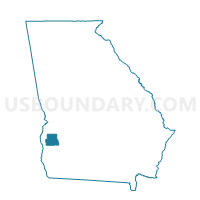
Outline

Summary
| Unique Area Identifier | 562733 |
| Name | 243718A - CUTHBERT Voting District |
| County | Randolph County |
| State | Georgia |
| Area (square miles) | 31.47 |
| Land Area (square miles) | 31.19 |
| Water Area (square miles) | 0.28 |
| % of Land Area | 99.13 |
| % of Water Area | 0.87 |
| Latitude of the Internal Point | 31.76851410 |
| Longtitude of the Internal Point | -84.77537850 |
Maps


Graphs
Select a template below for downloading or customizing gragh for 243718A - CUTHBERT Voting District, Randolph County, Georgia


Neighbors
Neighoring Voting District (by Name) Neighboring Voting District on the Map
- 243131 - COLEMAN Voting District, Randolph County, GA
- 243566 - BENEVOLENCE Voting District, Randolph County, GA
- 243718B - CUTHBERT Voting District, Randolph County, GA
- 243934 - CARNEGIE Voting District, Randolph County, GA
- 243947 - FOUNTAIN BRIDGE Voting District, Randolph County, GA
- 243954 - SPRINGVALE Voting District, Randolph County, GA
Top 10 Neighboring County Subdivision (by Population) Neighboring County Subdivision on the Map
- Cuthbert CCD, Randolph County, GA (5,821)
- Shellman CCD, Randolph County, GA (1,582)
- Benevolence CCD, Randolph County, GA (316)